|
The geology of the
UAE is very interesting, because traces of the
ancient events that shaped the land can still be
seen now, due to the scarcity of vegetation and
the ways in which erosion took place.
The rigid outer shell of the
earth (the “lithosphere”) is fragmented into
plates that can move, propelled by “currents” in
the underlying layer (the “asthenosphere”). Plates
can drift apart or closer together, a process
called tectonic movement.
Geologically, the UAE is part of a body of
continental rock known as the Arabian platform
which includes the Arabian Gulf and the Zagros
mountains of Iran as well as the area we know
today as the Arabian peninsula. For most of its
history the Arabian platform has been part of the
larger Afro-Arabian continent.
Around 500 million years ago, in the Cambrian era,
much of the Arabian landmass was covered by
shallow seas that evaporated in the hot climate,
leading to the formation of thick salt deposits.
Then movements of the Afro-Arabian tectonic plate
caused it to pass near the South Pole where it
went through an ice age, some 400 million years
ago.
Later more folding and faulting occurred in
Arabia. The seas flooded the area once again, in
the early Cretaceous (circa 130 million years
ago). In the major tropical ocean (the sea of
Tethys) that separated the Afro-Arabian continent
from the Eurasian landmass thick layers of
limestone and dolomite rocks were deposited. These
rocks of the late Permian to late Cretaceous era
(250-65 million years ago) are the rocks where the
UAE’s oil is found. These hydrocarbons were
created from abundant organic material (algae and
other micro-organisms) that were deposited in the
warm tropical seas of the time. The deposited
organic material was buried deeper and deeper and
was broken down by heat to form oil and gas.
|
 |
|
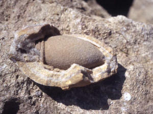
Fossil of the now extinct gastropod
Acteonnellid
|
During the Palaeocene and Oligocene (65-23 million
years ago) sea levels rose and fell several times.
The coastal region was periodically covered with
warm tropical waters. After that the area became
tectonically more stable but it began to separate
from Africa along the Red Sea Rift about 25
million years ago and is currently moving
northwards at an average rate of 5 cm per year. As
the Afro-Arabian plate moved north and was pushed
under Eurasia, the Zagros mountains in Iran were
formed. The western part of the sea of Tethys
disappeared and the straits of Hormuz closed. In
the rapidly subsiding basin thick layers of salt
and gypsum were deposited. The collision created
large scale folding in the Emirates, evidence of
which can be seen in Jebel Fayyah and Jebel Hafeet.
The UAE coast rose above sea level in the late
Miocene/early Pliocene (5 to 2 million years ago)
and the Arabian Gulf filled with water again about
4 million years ago. Fossil evidence shows that in
the late Miocene there were lush riverine valleys
in the west of Abu Dhabi with savannahs populated
by elephant, giraffe, rhinoceros and many other
animals.
About 8000 years ago the lowered sea level allowed
sand to be blown into Abu Dhabi from Saudi Arabia
and in the last 6000 years the Arabian climate has
become steadily drier.
|
 |
|
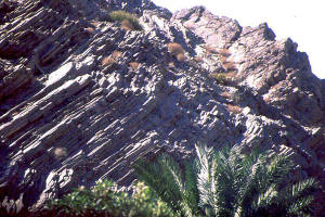
The layered and folded rocks of the Hajar
mountains can be studied at the surface
|
Most oceans have a
ridge of volcanic mountains running along the
centre. Due to volcanic activity, such a ridge in
the middle of the ocean can split, forming a new
part of the lithosphere, the so-called oceanic
crust. The two sides drift apart, a process called
seafloor spreading.
In the late Cretaceous, there was movement
originating from volcanic action in the part of
the Tethys sea that still remained to the east of
the Arabian landmass. This caused dark, dense
crustal magma extruded by the submarine volcanoes
to be pushed up over the edge of the Arabian
landmass, together with rocks from the layer
below, giving rise to a tremendously thick
sequence of so-called ophiolite rocks, which are
the main type of rock in the Hajar mountains.
Ophiolites are typical of such spreading centres
and provide the geologist with relatively rare
access to rocks that are amongst the most
representative of the deepest parts of the Earth’s
crust. In fact, the Hajar Mountain range holds the
most extensive area of ophiolites in the world and
is one of the few places on earth where these
oceanic crust rocks can be studied on land.
The beaches that bordered the ancient ocean folded
into mountains also. These are the fossil bearing
limestone outcrops that separate the gravel plains
from the Hajar range.
Erosion by wind and water has worn down many of
the mountaintops, while copious rainfall in the
past thundered down the mountains to form deep
wadis down their sides and wide gravel plains at
their feet.
SAND
The sands that cover the UAE from the Arabian Gulf
coast south to the uninhabited sands of the Empty
Quarter, the Rub’ al-Khali, are a more recent
geological feature than the oil-producing rocks of
the ancient Arabian landmass. It is the result
long periods of erosion and re-deposition in a dry
environment. The sand overlies the oil- and
gas-producing rocks that are not exposed to the
surface and are only known from drilling.
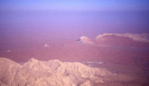 |
| An aerial view of Fossil rock partly
covered with red sand |
Throughout
the UAE the sand differs in colour and
composition, depending on its source.
Near the coast the sand is white, made up of
calcium carbonate, derived from the carbonate
sediments, seashells and coral reefs of the coast.
Further inland the sand consists of quartz
crystals, a stable end-product of the chemical
weathering of most types of rock. It can acquire
various colours through impurities or coatings.
For instance, red sand is quartz with amounts of
oxidised iron.
Black sand is derived from the igneous rocks of
the Hajar mountains.
A special type of white sand with perfect spheres
called ooliths is formed in tidal channels between
islands.
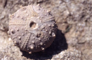 |
| Fossilised sea urchin Goniopygus
superbus |
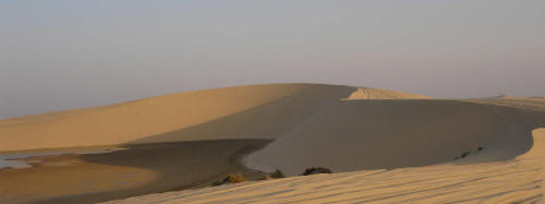
SAND DUNES
In principle sand dunes are formed by the force
and direction of the wind acting on the supply of
sand. In detail not much is known about the
formation of dune patterns.
The scale of the sand patterns ranges from ridges
of up to kilometers in length, dunes that are
measured in meters or multiples of meters. And
ripples that can be from a few to a hundred
centimeters in length.
There are three distinct types of sand dunes –
their shape depends on the direction and the
strength of the wind as well as on the type of
sand in the area.
Barchan dunes are sickle shaped, with a steep
concave slope on the down-wind side and gentler
convex slope on the windward side. They tend to
form where sand is relatively scarce and can often
be found on gravel plains or salt flats.
Transverse dunes are elongated sand ridges
perpendicular to the prevailing direction of the
wind. They usually lie parallel with flat sandy
plains in between. Again, the downwind side is
steep, while the windward side has a gentle slope.
Most of the dunes in the UAE are of this type,
with very high (up to 150 meters) transverse
ridges in and to the south of the Liwa oasis.
Longitudinal dunes are formed parallel to the
prevailing wind direction.
The processes that formed these long sand dunes
(called seif-dunes) are not clearly understood but
it is thought that they were formed during the
last ice-age, when winds were much stronger than
today. In the UAE they only occur in the extreme
southwest of the country, continuing deep into the
Empty Quarter.
The sand deserts of central and western parts of
the UAE have relict longitudinal dunes aligned in
more or less west-east orientation with a more
recent pattern of linear east-west ridges
superimposed.
Of course, combinations of sand dune shapes can
occur, so the patterns are often difficult to
recognize.
The major dune ridges in the UAE were formed in
the most recent ice age, some 18.000 years ago.
Glaciation helped the sand dunes to develop
because there were strong winds in the narrow area
between the ice front and the equator. In addition
the global sea level fell and this caused the
Arabian Gulf to fall dry, exposing the masses of
loose sediment that could be blown into dunes.
The prevailing wind direction in the UAE today is
from the north-west. Therefore active dune crests
are usually aligned from the north-east to the
south-west, with the steep face to the south-east.
In the west of Abu Dhabi emirate, there is an area
where in the Miocene period (6-8 million years
ago) a major river system existed in a subtropical
savannah. Many fossils of animals and plants that
no longer occur in the UAE were found deposited in
what is known as the Baynunah Formation.
Palaeontologists and geologists have carried out
extensive research there, most recently under the
auspices of the Abu Dhabi Islands Archaeological
Survey (ADIAS) and the Environment Agency-Abu
Dhabi (EAD). Some of the 51 species of fossils
found there are the remains of monkeys,
hippopotamus, crocodiles and elephants. The
existence of these animals of African origin is
proof of the fact that for a long time, until
about 5 million years ago, a land connection
existed between Africa and Arabia.
A very different array of fossils can be found in
the east of the country, in the row of Tertiary
limestone hills and mountains aligned along the
western flanks of the Hajar range. These sediments
used to be beaches and were folded up through the
spreading of the seafloor due to volcanic action
of submarine volcanoes.
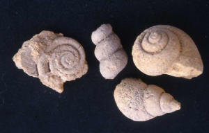 |
| Fossils of various species of
gastropods |
Many types of fossilized sea urchins, gastropods
and bivalves are present in places like Jebel
Huwayyah, Jebel Buhays and Jebel Fayyah, exposures
of what is called the Simsima formation. Of the 45
species of fossil sea urchins found in the Simsima
formation, 14 were new to science and some of
these have been named either after the place where
they were found or after the person who was
instrumental in finding them (for instance
Heterodiadema buhaysensis and Codiopsis lehmannae
– the latter named after a friend of the author)
One gastropod, the Acteonellid, became extinct
more than 50 million years ago but can still be
found as a fossil, sometimes in large numbers.
Another marine creature – an odd claw-shaped
bivalve called a rudist - became extinct at the
end of the Cretaceous period, 70 million years
ago.
Jebel Hafeet is the largest of these
fossil-bearing mountains – a major topographic
high rising nearly 1300 m above sea level, located
immediately south of Al Ain and straddling the
border between the UAE and Oman. It is easily
visible from space, and from below it looks like
“beached whale”, as Wilfred Thesiger once
described it. It is asymmetrical – on the west it
dips at about 25 to 30 º while on the east it is
much steeper. To geology students it is of special
interest, because the mountain is eroded in such a
way that the composing layers can be easily
observed at the surface.
In geology jargon Hafeet is the type locality for
two major formations: the Hafeet formation and the
Seniya formation. Both are rich in deep sea
planktonic fossils called foraminifera. At the
foot of the mountain, close to where the road from
the cement works passes through a man-made gap,
fossils of branching corals, oysters, gastropods
and more rarely sea urchins and pieces of
barnacles and crab claws can be found. One type of
fossil that is special to this mountain is called
Nummulites fichteli. They are thin round pieces of
rock, often a bit curved, the size of a coin
(hence the name). Where they are broken, a
delicate structure of circular and transverse
septi can be seen. These nummulites are the
remains of a now extinct one-celled organism.
The UAE are not only interesting as a finding
place for fossils, but also for rocks and
minerals. On Sir Bani Yas, a salt plug from the
inner core of the earth broke through to the
surface carrying with it ancient core rocks. One
of these very old (620 million years!) rocks can
be seen (and touched) in the Sharjah Natural
History Museum.
In the Hajar mountains beautifully coloured
interesting rocks are common – cherts, micah,
quartz, garnet, and calcites. Copper was present
in large enough quantities to be mined, making the
area famous in the days the Portuguese. The copper
used to be put in earthenware pots that had a
small round space in the bottom. The pot was
heated to such a high temperature that the copper
melted and collected in the bottom of the pot,
which was broken after cooling so that the coppers
ingot could be retrieved. The remains of mine
shafts and heaps of copper slag and pot shards are
found throughout the Hajar mountains.
Whereas the Hajar (rocky) mountains were aptly
named, Jebel Hafeet is a misnomer for a mountain
that is all but empty! For those who develop an
eye for nature, every corner of the country holds
surprises and the possibility to discover
sometimes still unknown objects.
|