|
Anyone
who has had the pleasure of roaming the
palm groves that are tucked away in the
Hajar Mountains has come across the narrow
channels that carry the water from
collection ponds to the small square plots
of palms, citrus and mango trees, banana
groves and alfalfa. In the old
plantations, the channels are made of mud
or rocks and they meander romantically
among the weeds that grow along their
sides, benefiting from leaking water. In
other places new cemented channels have
been made. They draw straight lines
through the fields, and since they do not
leak as much water, the weeds are less or
non-existent. For a natural history
enthusiast like myself, the old systems
are much more interesting. Many pretty
flowers exist by the grace of the
irrigation water as do the various species
of dragonflies and damselflies, the toads
and the little wadi fishes.
It is
fascinating to watch plantation workers
implement the irrigation system. It
works this way: the water is channeled
from mountain sources far away to large
basins or pools at the edge of the
plantation. From there a network of
surface channels criss-crosses the
plantation. Wherever a channel branches
from a main channel a sluice is
constructed, either from a piece of
metal or from some rocks or sometimes
even from a wad of old rags. The water
runs to a set of fields and floods them,
and when the trees are standing in a
layer of water, the sluices are opened
to the next set of fields. In this way
the available water is divided over the
entire plantation in the course of a day
or so. At night the collection pool
fills up again and the next day the
process starts from the beginning.
For many
years I thought that these channels were
called "aflaj", the plural of "falaj".
Only recently did I learn that this name
actually only belongs to the part of the
irrigation system that runs underground.
The surface channels that can be seen
above ground are called "ghayl" - a name
that is also given to several settlements
in the country.
Most of the
rain in this country falls in the
mountains, where isolated thunderstorms
cause precipitation even during the hot
summer months. In various places in the
Hajar Mountains there are streams that
have permanent running water, or at least
deep pools that contain water for a long
time even in years of drought. These water
sources have been used since many
centuries to provide water for the fertile
soil at the foot of the mountains. Al Ain
is the prime example of a huge oasis that
exists by the grace of the mountain water
resources and the ancient irrigation
system that brings the water across many
kilometers of mountains and gravel plains
to the place where gardens were created on
the alluvial soils that were deposited at
the foot of the mountain range.
Irrigation systems like the ones that
exist here are known from other places in
the world, as far apart as Europe (Spain)
and Central Asia. The most sophisticated
systems so far were from Iran and
Afghanistan. Those are called "qanat" or "kahriz"
and were long thought to be the oldest
systems, having been reported fro the
first time in reports by the Assyrian kin
Sargon II in 714 BC. The art of making
these systems was long thought to have
come to Arabia from Iran and Iraq.
However, recent archeological studies have
revealed that the underground irrigation
channels that occur along the western side
of the Hajar Mountains in the UAE and Oman
preceded these "qanat" by a few centuries.
It could very well be that the engineering
skills needed to build these intricate
waterways passed the other way. The fact
that the word "qanat" is Arabic is another
indication that the underground irrigation
systems originated in the Oman peneinsula
rather than in Iran.
 Dr Walid Yasin al Tikriti, Adviser of
Archaeology at the Department of
Antiquities and Tourism in Al Ain
conducted several digs that laid bare deep
underground channels that have been dated
to 1000 years BC. None of the Irani "aflaj"
are this old. The newly discovered
channels were lined with pavement slabs of
rock, and were highly sophisticated.
Workers from special tribes, such as the
Al Awamir, who were experts at this kind
of work, dug them far underground. Their
descendants are still living in the region
and have worked to restore the old systems
as recently as 50 years ago.
Dr Walid Yasin al Tikriti, Adviser of
Archaeology at the Department of
Antiquities and Tourism in Al Ain
conducted several digs that laid bare deep
underground channels that have been dated
to 1000 years BC. None of the Irani "aflaj"
are this old. The newly discovered
channels were lined with pavement slabs of
rock, and were highly sophisticated.
Workers from special tribes, such as the
Al Awamir, who were experts at this kind
of work, dug them far underground. Their
descendants are still living in the region
and have worked to restore the old systems
as recently as 50 years ago.
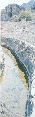
The
channel started at the source of the water
in the mountains or at an underground
source tapped by a mother well. It had to
descend at a certain angle in order to
cause the water to flow gently with the
force of gravity. The angle had to be
calculated exactly, so that the channel
would reach the fields that were to be
irrigated at precisely the correct level.
Every hundred or so meters an airshaft had
to be dug to the surface, called "tuqbah"
(pl. "tuqab"), in order to provide the
workers below ground with air, and to
facilitate maintenance work on the
channels later on. Closer to the fields in
the plains, the channel would become a
deep ditch rather than a tunnel. However,
in order to prevent evaporation and
pollution, this ditch was then covered
with slabs of rock or bricks. These are
called "cut-and-cover sections". A large
basin – the “shari’ah - was made at the
point where the water ran at surface
level. This basin was a collection area
and often also used as a washing place. It
was lined with flat slabs of rocks. In one
location at Bina bin Sa'ud near Al Ain a
long steep staircase leads down to the
shari'ah. (It was this find that provided
data for the age of the system: more than
300 sherds of pottery were found during
the dig to the level of the shari'ah 3.8 m
below the present ground surface. The
sherds were of Iron Age pottery, dating
back some 3000 years).
Beyond
the basin a network of smaller surface
channels (the "ghayl") led to the fields
that needed irrigation. As time went on
the irrigation system sometimes had to be
deepened in order to keep flowing. This
would cause the whole system to end a bit
further away at a slightly lower
elevation. Fields and settlements would be
moved accordingly.
Iron Age
"aflaj" have been found so far in Al Ain's
Hili, Bida bin Saoud, and further north in
the Jebeeb and Madam areas. In Oman such
old systems have been found in the Maiyser
and Raki areas. In Oman two Iron age
ceramic bowls were found alongside the
aflaj. In Hili in two locations some large
buildings were unearthed close to the
shari'ah. These are considered to be
administration sites for the distribution
of the precious water and have been given
the name "bayt al-falaj"
Dr Al
Tikriti who has been working in the UAE
for thirty years, has written a book about
these ancient "aflaj" which has been
published in Arabic already and is being
translated into English now.
Even in this age of modern technology, the
system of "aflaj" and "ghayl" is still
functional. Since it does not depend on
engines that can break down or on pipes
that can rust and burst, it has been
operational without fail for up to 3000
years. The only work it needed was
cleaning the channels of rubble from time
to time, especially after strong rains.
His Highness the President, Sheikh Zayed
launched a program for the restoration and
renovation of water resources, including
the "falaj" systems, at the time when he
was governor of Al Ain in the late
nineteen forties. This restoration program
took 18 years and provided the water that
made the area famous for its agricultural
progress.
|